A BIRD’S EYE view of Melbourne’s boom suburbs show just how quickly they’ve changed in the last five years.
Wyndham in Melbourne’s west, Casey in the south east, Whittlesea in the outer north and Melbourne’s CBD dominate the list of the top 10 fastest growing regions in Australia.
Nearmap, an aerial imagery company, used Bureau of Statistics data to create a visual aerial transformation of suburbs that experienced the highest percentage of population growth between 2011 and 2016.
University of Melbourne research fellow Dr Matthew Palm said there were many reasons why people flocked to the suburbs.
“I think it’s the failure to provide affordable housing in the core,” he said.
“Certainly there may be a few people who like that certain lifestyle, but largely there is a lack of affordable (housing) options close to the core.”
Dr Palm said Melbourne had a lack of ‘middle density’ housing, like townhouses with backyards, particularly in inner-city suburbs.
“Folks are living longer. Boomers who started their families in the inner suburbs … those homes are not turning over for younger families,” he said.
“We are missing that middle density accommodation and as a result all the pressure is being channelled out (of Melbourne).”
Nearmap CEO Rob Newman said a lot had changed in five years.
“From the ground it can be difficult to see the pace at which Australia is growing,” he said.
“But when you look at it from the air, you can observe in incredible detail the change occurring across our country, even just in the last five years.”

MELBOURNE CBD
Melbourne City is the third fastest growing area in Australia. The population jumped 45% in five years up from 93,612 to 135,969.
Melbourne Park
In five years we’ve seen an upgrade of Olympic Park and a new National Tennis Centre Tennis World in 2013.
“It’s prime real estate. It was only a matter of time before that was completely built up,” Dr Palm said.

Melbourne Park in January 2012. Picture: Nearmap.

Melbourne Park in January 2017. Picture: Nearmap.
Carlton
The aerial images show the block between Rathdowne and Drummond streets, near Princes St.
A new Rathdowne Place aged care centre has cropped up, as has the Rathdowne Place and Wellness Centre.
Dr Palm said it was only a matter of time before Carlton was built up.
“It’s close to the CBD and has the enormous economic generator the University of Melbourne,” he said.
“A lot of inner suburbs are wrapping up as old industrial neighbourhoods.”
“We are seeing the last waves of an industrial town to an information economy.”

Carlton in November 2011. Picture: Nearmap.

Carlton May 2017. Picture: Nearmap.
Docklands
The Victoria Harbour Docklands precinct has been built up in five years.
We’ve seen new additions to the skyline, including The Exo apartment complex, a Woolworths shopping centre, Westpac and the new Melbourne headquarters.
“It’s close to the CBD. There are potential opportunities for people to capitalise on the national amenities, like the mouth of the river,” Dr Palm said. “We aren’t there yet.”

Docklands in 2012 and 2017. Picture: Nearmap.
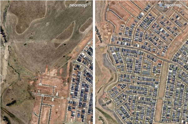
WYNDHAM
An extra 34% of people now live in Wyndham compared to 2011. The population grew from 166,020 to 221,895.
Dr Palm said Wyndham was an appealing place for families to live.
“It’s not too far from existing public infrastructure and there is a train line,” he said.
Truganina

Truganina in November 2011. Picture: Nearmap.

Truganina in May 2017. Picture: Nearmap
Point Cook

Point Cook GIF. Picture: Nearmap.
Wyndham Vale
Wyndham Vale January 2012 and 2017. Picture: Nearmap.
CASEY
Casey’s population grew from 128,361 to 168,177 (up 31%).
Dr Palm said there were many reasons why the outer south eastern suburb had boomed.
“Melbourne has historically grown south and east,” he said.
“You can go as far out in those directions as you want. However that development has shifted to the north and west.”
Casey has seen many new shopping centre developments like Spring Hill, a redevelopment of Casey Central, the Homemaker Centre and the Avenue in Cranbourne North.
The Botanic Ridge development, near Pearcedale and Browns Rd, has also expanded.
Dr Palm said the southeast was closer to the water and more appealing to some.
Cranbourne West

Cranbourne West in January 2012. Picture: Nearmap.

Cranbourne West in March 2017. Picture: Nearmap.
Cranbourne North

Cranbourne North GIF. Picture: Nearmap
Cranbourne East

Cranbourne East 2011. Picture: Nearmap

Cranbourne East 2017. Picture: Nearmap
Botanic Ridge

Botanic Ridge August 2011. Picture: Nearmap

Botanic Ridge March 2017. Picture: Nearmap
WHITTLESEA/WALLAN
The Whittlesea area grew 28% in population from 166,907 to 213,708.
Dr Palm said traditionally Melbourne grew outer south and east, but more people were moving to the north.
He said that population shift could impact our farmlands if the trend continued.
“I wouldn’t say (we should move) up. I would build a little bit more in the inner suburbs,” he said.
“Our food security is more important and long term that’s not going to be good for our country.”
Doreen

Doreen December 2010. Picture: Nearmap.

Doreen February 2017. Picture: Nearmap.
Wollert

Wollert January 2012. Picture: Nearmap.

Wollert February 2017. Picture: Nearmap.
This article was originally published by Kara Irving for the Herald Sun, August 9, 2017.